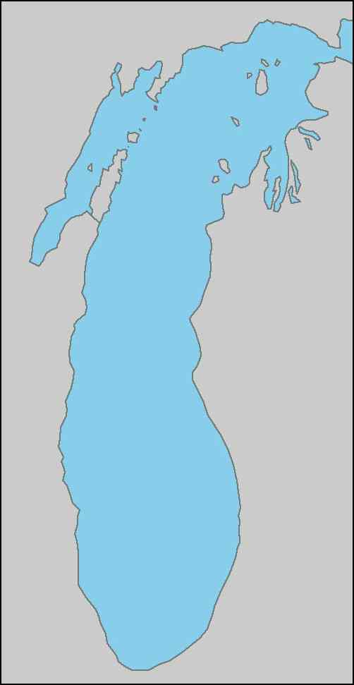
Hover over a map marker to see the name of the light and click the marker to open a window containing additional information
Open to the public
Not open to the public
Michigan City
Ludington
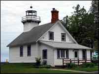
Traverse City
South Haven
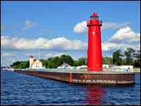
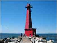
Muskegon
Holland
Frankfort
Green Bay
Menominee
Escanaba
Manistique
Mackinaw
City
Chicago
Milwaukee
Racine
Sheboygan
Visit our Gift Shop in Mackinaw City at 707 N. Huron Ave. - Right across the street from Old Mackinac Point Lighthouse
Contact: Tel 231-436-5580 Fax 231-436-5466 Mail PO Box 219, Mackinaw City, MI 49701 Email[email protected]
St. Joseph
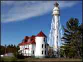
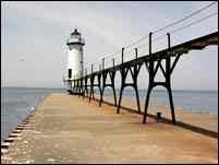
Both pierhead light and fog signal building were built in 1907. Buildings are closed to the public, however close views can be had from the pier In good weather.
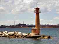
Erected in 1903 to replace a decayed timber beacon, the lighthouse is currently closed to the public, but can be seen close up by parking at the west end of Water Street and walking the pier
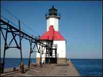
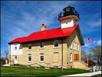
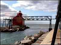
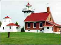
Erected in 1902, the lighthouse is owned by the Michigan Lighthouse Conservancy. Not yet open to the public, the pier can be accessed from the north end of Lakeshore Drive
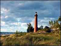
The majestic brick tower is all that remains of the 1874 light station. The tower is opened for climbing throughout the summer by the SPLKA. Take Silver Lake Road out of Silver Lake and follow the lighthouse signs
Erected in 1917 to replace a deteriorating 1873 timber beacon, good views of the Pentwater South Pierhead light can be obtained from the north pier at the west end of E. Lowell Street.
The 1927 lighthouse on the end of the north pier is owned by the City of Manistee, but is not currently open to the public. Take Lakeshore Drive to the park and walk onto the pier for a close up view.
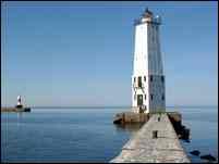
The lighthouse was relocated from a former north pier to its current location in 1932. Now owned by the City of Frankfort, the lighthouse is not yet open to the public, but close up views can be had by walking out the breakwater from Main St.
Built in 1935 to replace a lightship, this light is Coast Guard owned and closed the public. Good views of the light can be had from the Manitou Island Transit boat on the way to and from South Manitou Island
The 1867 lighthouse is located in Ludington State Park, and is opened to the public throughout the summer by the Sable Points Light Keepers Association (SPLKA). Take N Lakeshore Dr out of Ludington approximately 6 miles, then walk 1 ½ miles to the lighthouse.
The 1851 lighthouse was abandoned in 1913, and is now owned by the Waugoshance Lighthouse Preservation Society, and is easiest seen on Shepler’s westbound lighthouse cruises out of Mackinaw City.
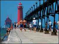
Built in 1907, this structure served as a rear range to the outer light. Now owned by the City of Grand Haven, the light is not yet open to the public, but can be viewed up close from the pier.
The 1872 lighthouse is part of the Sleeping Bear National Park, and can be accessed by regular passenger service provided by the Manitou Island Transit.
Built in 1858 to replace an 1851 structure, the lighthouse is owned and operated as a summer school for challenging teens by the Charlevoix School District and the grounds and lighthouse are open during the summer.
Ile aux Galets
The 1881 tower is all that remains after all other buildings were demolished in the 1980’s. Owned and operated by the Coast Guard’ the tower can be seen on Shepler’s extended westbound lighthouse cruises
Established in 1867, the lighthouse is under restoration by the Fox Island Lighthouse Association. Access is currently only possible by private or charter boat.
Owned and restored by Benzie County and Friends of Point Betsie, the 1858 lighthouse is open for tours most weekends, Fridays & and Holidays Memorial Day through mid October
Built in 1948 to replace a deteriorated 1885 timber beacon, the lighthouse is not open to the public, but the pier can be accessed from the park at the foot of Grant Street.
Established in 1909, this light is owned and operated by the Coast Guard, and can be seen on Shepler's westbound lighthouse cruises out of Mackinaw City
Built in 1876, the lighthouse is opened to the public throughout the summer by the SPLKA. Take Southshore Dr west out of Whitehall and follow the lighthouse signs
White River
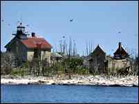
Established in 1873, the GLLKA began restoration in 1983. With the help of thousands of volunteers, Boy Scouts & Girl Scouts, the station has been returned to its original glory. Access by private boat or Shepler’s westbound lighthouse cruise out of Mackinaw City
The 1884 lighthouse is part of Harbor Point Association and land access is unavailable. Stafford’s Pier Restaurant in Harbor Springs operates “The Pointer” boat which offers tours of the bay with views of the lighthouse.
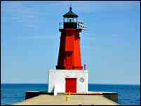
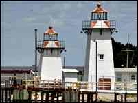
First lighted in 1927, the pierhead lighthouse is owned by the City of Menominee, but is not open to the public. Walk along the breakwater from the parking area at the south end of Harbor Dr.
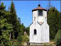
The dwelling of the 1865 lighthouse burned to the ground in 1959. Part of the Hiawatha National Forest, the park is open to the public. Take County Rd 518 to the end of Stonington Peninsula to the park entrance.
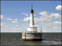
Built in 1935 to mark a shallow area off the track into Escanaba harbor, the lighthouse is owned and operated by the Coast Guard, and can only be seen by private or charter boat.
Initially lighted in 1905, this light station is owned by Little Traverse Band of Odawa and the Coast Guard maintains the light. It can only be seen by private or charter boat.
First lighted in 1914, the lighthouse is now privately owned, but is not open to the public. Walk along the breakwater from the parking lot on E Lake Shore Drive east of town.
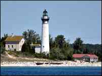
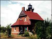
The 1895 light station is owned by the State of Michigan and interpreted by the Gulliver Historical Society. Open for tours Memorial Day through mid October.
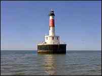
Built in 1928 to replace the Squaw Island lighthouse, Lansing Shoal light is owned and operated by the Coast Guard, and can only be seen by private or charter boat.
Built in 1892, the Squaw Island light was rendered obsolete by Lansing Shoal. The island is privately owned and can only be seen by private or charter boat.
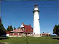
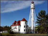
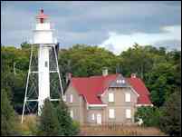
Built in 1869, extinguished in 1906 and sold into private ownership in 1913, the lighthouse was purchased by Emmet County in 2008. Relighted in 2009, the entire station is being restored and is open for tours from May through early November. Take Central Ave west out of Mackinaw City until it ends, and turn right.
Built in 1858 to replace a deteriorating 1837 structure, the lighthouse is now owned by the Michigan City Historical Society, and operates as a fully restored museum from April through October. Take Pine street north to Washington Park.
Built in 1858 to replace a deteriorating 1837 structure, the lighthouse is now owned by the Michigan City Historical Society, and operates as a fully restored museum from April through October. Take Pine street north to Washington Park.
Erected at the outer end of the breakwater at the man-made US Steel harbor at Gary in 1911, the lighthouse still serves boats entering to unload steel, coal and limestone. Located within the private harbor, a private or charter boat is the only way to see this light.
Erected at the outer end of the breakwater at the man-made Universal Portland Cement Company harbor at Buffington in 1927, the all concrete lighthouse still serves boats entering to unload limestone. Located within the private harbor, a private or charter boat is the only way to see this light.
Erected at the outer end of the breakwater at the man-made Universal Portland Cement Company harbor at Buffington in 1927, the all concrete lighthouse still serves boats entering to unload limestone. Located within the private harbor, a private or charter boat is the only way to see this light.
Erected at the south of the breakwater at the man-made Calumet harbor in 1936, the tower formerly served at Holland. Located far from shore, a private or charter boat is the only way to see this light.
Built in 1892, the 68th Street Water Intake crib was one of a number of such cribs which supplied water to Chicago. Located 1 ½ miles in the lake, a private or charter boat is the only way to see this structure.
Built in 1898 and relocated to its present location in 1918, this impressive structure guides mariners through the main entry in the breakwater. Located a mile offshore, a private or charter boat is the only way to see this light.
Formerly located on the pier in Kewaunee, the light was erected at the entrance to the Chicago canal lock. While it can be seen from Navy Pier, it is best seen by private or charter boat.
The Harrison crib water intake (right) was built in 1927 and the William E Dever crib (left) built alongside it in 1935. Located almost two miles from shore, they are best seen by private or charter boat.
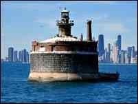
While under construction, it was found that the crib had settled on one side and had to be jacked up. Completed in 1915, this crib is almost two miles from shore, and best seen by private or charter boat.
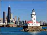
Established in 1874 to serve as the primary leading light into Chicago, the lighthouse is now owned by the city of Evanston as part of its Lighthouse Park District, and is open for tours May through September. Located at the intersection of Central Street and Sheridan Road in Evanston.
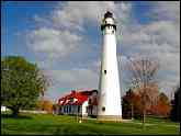
The light was established on the south pierhead in 1899 to replace an aging 1849 shore light. Once backed-up with a large fig signal building, the structure burned in 1967, leaving only the 1899 tower. Take Mathon Drive west and turn south on Pershing to the pier for close-up views.
Built in 1866 to replace a crumbling 1848 structure, the lighthouse is now owned by the Kenosha History Center and has been restored and is open to the public from mid may through October. Take 50th street east, cross the bridge to Simmons Island and turn right onto 4th street to the lighthouse.
While a timber frame light was erected on the pier in 1856, it was replaced twice before this cast iron tower was erected in 1901. Continue on 4th street after visiting the Southport light and walk out the pier for a close-up view.
Built in 1906 to replace an unsuccessful automated Pitsch gas light, the Racine Reef light was one of the most impressive lights on the Great Lakes. Demolished in 1961 and replaced by this pierhead style beacon the light is located over a mile from shore and can only be seen by private or charter boat.
Established in 1880, the light house is now owned by the village of Wind Point and is under the care of the Friends Of Wind Point. The lighthouse grounds are open to the public, and tower climbs are offered a number of times over the summer. Take 3 Mile Road west to Lighthouse Drive and follow north to the lighthouse.
Located on the breakwater off Racine in 1924, the lighthouse was rendered obsolete by the installation of a modern aid in 1987, and the city of Racine saved and moved the light to the outer wall of the city’s large marina where it can be seen to this day.
A cream city brick lighthouse was erected on the north pier in 1866. The piers were extended and the light extinguished in 1901, the tower removed and the building became part of the lifesaving station. It still stands today, much modified.
Milwaukee's first light was located on the timber pier in 1848, and as the piers were extended a number of lights were installed. The current cast iron light was erected in 1906, and has been moved a number of times. You can gain access to the pier from Henry W. Maier Festival Park
The first light on the Milwaukee breakwater was established in 1902. After a number of rebuilds, this major station was erected in 1929. The lighthouse was recently transferred to the non-profit “Optima Enrichment” and they hope to restore the station and open it to the public by 2016. For now, with the breakwater disconnected from shore, a private or charter boat is the only way to get a close up view.
The first light at Milwaukee's North Point was established in 1854. With the bluff crumbling beneath it, a new station was built in 1888. Obscured by trees, the tower was elevated in 1913. The light has been completely restored by the Friends of North Point lighthouse and is open weekends from 1:00 to 4:00.
The cream city brick lighthouse on the bluff in Port Washington was built in 1860 to replace a crumbling brick structure built in 1849. After construction of the pierhead light in 1903, the old light was discontinued. It has been restored by the Port Washington Historical Society and is open to the public May through October.
The first light was established on the breakwater in 1889. The existing concrete and steel tower was erected in 1935. The tower is still Coast Guard property, but you can walk the breakwater for close views of the lighthouse.
Port Ulao was founded in 1847 when a 1,000 foot pier was erected. While $3,500 was appropriated to erect a light on the pier in 1850, no light was built until 1981 when Brana Kevich built this lighthouse home atop the bluff. It is someone's home so please honor the owner's right to privacy.
Sheboygan’s first light was built in located on a point north of the harbor in 1839. A light was placed on the pier in 1873, and a light on the breakwater in 1900, with the existing steel tower erected in 1915 and its lantern removed after automation. On calm days you can walk out the breakwater for a close up view.
The first light in Manitowoc was established on shore in 1839 and augmented by a pierhead light in 1873. After a major reconfiguration of the harbor, a light and fog signal were erected on the new north breakwater in 1895, and rebuilt to its current configuration in 1919. The breakwater is open to the public but the light privately owned.
The first lighthouse to guide mariners was erected on shore here in 1852. With the construction of piers at the river mouth, the old light was demolished and a pierhead beacon erected in 1886. Sadly deteriorating, the old structure was removed and transported to the Rogers Street Fishing village in 1971, where it was restored and can be visited today.
Originally known as Twin River Point, the station was renamed Rawley Point in the early 1950's. The light station was established in 1874 and was built to the same plan as Outer Island, among others. Built of a poor quality brick, the tower was largely razed in 1894 and a skeletal iron tower previously used on the pier at Chicago was erected on the site. Rawley Point is now a state park.
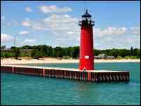
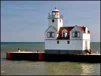
To help guide mariners into the busy fishing community, a typical timber frame beacon was erected at the end of the north pier here in 1893. This circular steel tower was erected in 1908 after the piers were rebuilt and extended. The light was lifted onto the circular steel base in 1932 to increase its focal plane.
While the Sturgeon Bay pierhead light served to guide mariners into the opening of the canal, it was not significantly elevated to serve as leading light to the entry from out in Lake Michigan. To this end, the Sturgeon Bay Canal light was established in 1899. A simple cylinder, it was subject to vibration, and was supported with exterior columns in 1903. It is a twin to the light at Devils Island.
As work on the Sturgeon Bay Ship Canal drew to completion in 1882, a pier was erected at the east entrance and as mandated by Congress, the Lighthouse Board erected a light at its outer end in 1882. Two years later, a corrugated iron steam fog signal building was erected behind the beacon. This structure was itself replaced in 1903 with this surviving combination light and fog signal.
The old main light did not do a good job of guiding mariners into the bay, so a pair of range lights were built in 1869 and lighted on the opening of the 1870 navigation season. Both lights are now part of the Ridges Sanctuary and can be seen from the trails. They are open to the public during the Door County Lighthouse Festival.
Really for purely political reasons in 1852, the light served as neither as an effective coast light nor as a guide into the harbor, and was replaced by the Cana Island light and the Baileys Harbor Range in 1870. The lighthouse and small island on which it sits is now privately owned and difficult to see, the best view being from private or charter boat.
Built in 1870, the cream city brick on the tower deteriorated and the tower was wrapped with iron bands in 1902. The lighthouse is now managed and under restoration by the Door County Maritime Museum and is open to the public May through October. Parking has also been greatly improved.
The first light to guard Death's Door was located on Plum Island. Difficult to see from Lake Michigan, a new light was established on Pilot Island in 1858. Equipped with one of the loudest fog signals on the lakes, the station saved many lives. Now under stabilization by the Friends of Plum and Pilot Islands, the light can only be seen by private or charter boat.
Even after the Pilot Island light was established in 1858, mariners complained of difficulty locating the passage through “The Door” from the east, and the Plum Island Range lights were established as a guide in 1897. Now under the stewardship of the Friends of Plum & Pilot Islands, the lights can best be seen from private or charter boat.
Eagle Bluff’s third-and-a-half order Fresnel lens first exhibited on the night of October 15, 1868, it was built to the same “Norman Gothic” plan as its sister lights at McGulpin Point, Sand Island and White River, among others, but is the only sister with a square tower. Managed by the Door County Historical Society, the lighthouse is open May through mid October.
In order to decrease navigation distance around the Door peninsula, the Sturgeon Bay Ship Canal was cut through from Lake Michigan in 1882, and the Sherwood Point lighthouse established to mark its western entry in 1883. The light is operated as R7R station for Federal employees and is open during the Door County Lighthouse Festival.
Completely blocking the entrance to the Fox River, mariners had to circumnavigate Grassy Island. The Corps of Engineers dredged a cut through the island in 1867, and range lights were erected on the cut 1872. Virtually all of the island was later removed, and the range lights saved and moved to the Green Bay Yacht club, where they have been beautifully restored by club members.
Long Tail point protrudes into Green Bay from its western shore. The rubble stone Tail Point light was erected to mark the point in 1848. Poorly built, the station was replaced in 1859, and that second structure replaced by a crib light off the point in 1899. The crib structure was destroyed in a 1973 storm, leaving the crumbling 1848 tower as the only remnant of any of the three structures. Visible only from private or charter boat.
Located approximately midway across the bay, a lighthouse was established on the northwest point of the island in 1868. The structure is built to the same plan we saw earlier in the trip on Sand and Passage Islands. Its lantern removed in 1958, the lighthouse is now part of Gibraltar Park and is open to the public during the Door County Lighthouse Festival.
Lying five miles off the Menominee River, the lighthouse on Green Island was built in 1863, a twin if the Port Washington lighthouse. Automated in 1933, the light was abandoned and subject to vandalism, the old cream city brick structure deteriorated quickly, with these walls being all that remains. Only visible from private or charter boat.
The Peshtigo Reef light was established in 1936 to replace a series of lightships which had marked the dangerous reef since 1906. The station was never manned, being remotely controlled by radio signals sent from the Sherwood Point light station across the bay. The light is only visible from private or charter boat.
Established in 1935 to mark the entrance into the channel leading down to the Fox River. Although very similar in appearance to the remotely controlled Peshtigo Reef light, this light was a manned station, and served by three-man crews until its automation in 1979. Only visible from private or charter boat.
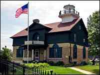
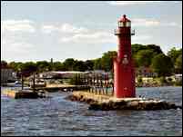
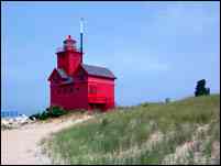
The 1907 "Big Red" lighthouse is owned by the Holland Harbor Lighthouse Historical Commission. With the pier on which it is located being in a gated community, it is best viewed from Holland State Park on the north shore of Lake Macataw
Built in 1891 four miles in the lake to avoid intake of contaminated water nearer the shore. The structure can only be seen by private or charter boat.
Built close to the shoreline in 1870 and one year later burned to the ground, a new light was erected in 1872. Rendered obsolete by the pierhead light the building was sold into private hands and moved from the site in 1993 to serve as a private dwelling, to which purpose it still serves West Melitzer Street at the end of Third Avenue
Erected in 1903 at the same time as the new steel and iron south pierhead light, this was an automated light from the day it was established, illuminated with acetylene and kept bye the Pierhead light keepers. Now under the stewardship of the Michigan Lighthouse Conservancy, you can walk out the breakwater to obtain close up views of this light.
Aging and difficult to see from the water, the Sand Point lighthouse was replaced by the Escanaba Crib light in 1940. The light and contained diaphragm fog signal were powered by city electricity delivered via a submarine cable. Good views can be had from Water Plant Road near the end of Sand Point, but close up views can only be had from a private or charter boat.
Dunlap Reef was a dangerous obstruction lying in the path of mariners passing through the canal. A pair of range lights was established to mark the reef in 1881. After being replaced by a new light and buoys in 1924, the front light was demolished and the rear light sold and moved across the ice into town where it still serves as a private dwelling at 411 S. 4th Avenue. You can see the building from the street, but please respect the owner’s privacy.
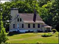
Cedar River was a minor lumber town, but the owner of the mill had sufficient “pull” to convince the government that a light was needed here. Established in 1891, the station consisted of a dwelling and service building with what was virtually a tall timber pierhead beacon attached. The mill burned in 1912 and traffic in the harbor dwindled. The tower was demolished and the dwelling sold into private hands. Located on the inside curve in an unnamed road to the south of the river you can see the dwelling from that road.
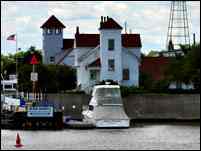
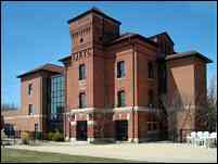
Built in 1893 this building and its wharf and outbuildings served as the primary supply depot for the aids to navigation on Lake Michigan. It was replaced whit the construction of a new depot in Milwaukee and closed in 1917 when it was transferred to the Navy.The property and buildings are now part of the St. Joseph River Yacht Club.
With so many buoys spread throughout northern Lake Michigan, it consumed too much time transporting them too and from the depot in St. Joseph, so this buoy depot was established in 1901. Now serving as the Charlevoix Coast Guard station at the foot of Coast Guard Drive, the building is best seen by private or charter boat.